 Tools
Tools Tools
ToolsRandall, C., 2020. Later Prehistoric and Romano-British occupation at Townsend farm, Poyntington. Geophysical survey and evaluation 2010-11. Proceedings of the Dorset Natural History & Archaeological Society, 141.
Full text available as:
Preview |
PDF
Randall_poyntington.pdf - Accepted Version Available under License Creative Commons Attribution Non-commercial. 148kB |
Preview |
Image (TIFF)
Randall_Poyntington_Fig_2.tif - Accepted Version Available under License Creative Commons Attribution Non-commercial. 15MB |
Preview |
Image (TIFF)
Randall_Poyntington_Fig_3.TIF - Accepted Version Available under License Creative Commons Attribution Non-commercial. 999kB |
![[thumbnail of Randall_Poyntington_Fig_4.jpg]](https://eprints.bournemouth.ac.uk/33724/13/Randall_Poyntington_Fig_4.jpg "Randall_Poyntington_Fig_4.jpg") 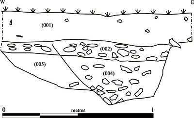 Preview |
Image (JPEG)
Randall_Poyntington_Fig_4.jpg - Accepted Version Available under License Creative Commons Attribution Non-commercial. 120kB |
![[thumbnail of Randal_Poyntington_Fig_5.jpg]](https://eprints.bournemouth.ac.uk/33724/18/Randal_Poyntington_Fig_5.jpg "Randal_Poyntington_Fig_5.jpg") 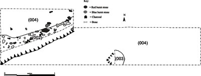 Preview |
Image (JPEG)
Randal_Poyntington_Fig_5.jpg - Accepted Version Available under License Creative Commons Attribution Non-commercial. 171kB |
|
Copyright to original material in this document is with the original owner(s). Access to this content through BURO is granted on condition that you use it only for research, scholarly or other non-commercial purposes. If you wish to use it for any other purposes, you must contact BU via BURO@bournemouth.ac.uk. Any third party copyright material in this document remains the property of its respective owner(s). BU grants no licence for further use of that third party material. |
Abstract
Geophysical survey and trial excavations were carried out on two fields, Hanglands and Fairmile, at Townsend Farm, Poyntington, Dorset. Gradiometry was carried out across the entirely of Hanglands. Despite having been seriously affected by ploughing it produced evidence of linear cut features and included curvilinear anomalies possibly representing roundhouses. Three evaluation trenches were positioned with the aim of characterising the geophysical anomalies, understanding the quality, preservation, and gaining some chronological understanding. Despite considerable truncation by ploughing, an enclosure ditch and a curvilinear gully of later prehistoric date were identified as well as an undated terrace along the break in slope on the eastern side of the field, which could be Romano-British or medieval. Gradiometry over a small area at the north end of Fairmile, identified anomalies on a rectilinear alignment where Romano-British pottery had been recovered from the surface, including a South East Dorset Orange Wiped Ware sherd of the late 4th-early 5th century AD. The anomalies are suggestive of a substantial Romano-British building and associated features. The limited investigations have demonstrated an area of later Iron Age occupation adjacent to what appears to be a a previously unrecorded villa.
| Item Type: | Article |
|---|---|
| ISSN: | 0070-7112 |
| Group: | Faculty of Science & Technology |
| ID Code: | 33724 |
| Deposited By: | Symplectic RT2 |
| Deposited On: | 09 Mar 2020 12:44 |
| Last Modified: | 14 Mar 2022 14:21 |
Downloads
Downloads per month over past year
| Repository Staff Only - |